Castles, mountains, sea – want to see as much of the island as possible in as little time as possible? Here are three day tours by car that cleverly combine the Isle of Skye’s main sights.
info on Skye:
» General
» Getting there
» Best time to travel
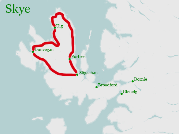
» Round trips
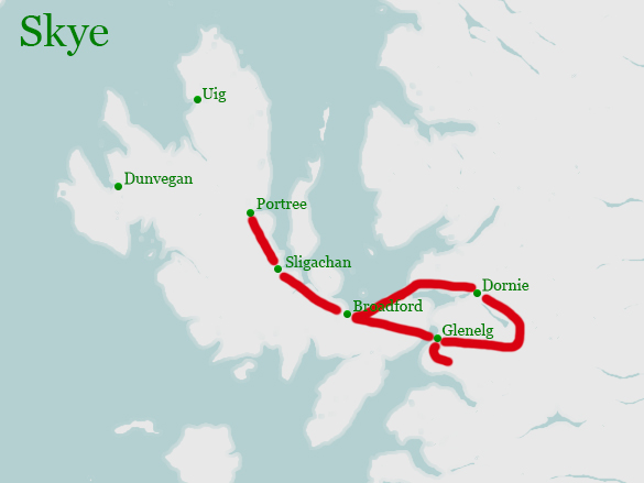
The starting point for each of our tours is the capital Portree. Each of the tours can easily be done in a day, but are quite densely packed. You can, of course, break them up into smaller bites or change direction. The suggestions are meant to be an inspiration – three options I’ve already tried.
Taken together, the tours show the whole character of the island, but of course cannot include every single little sight.
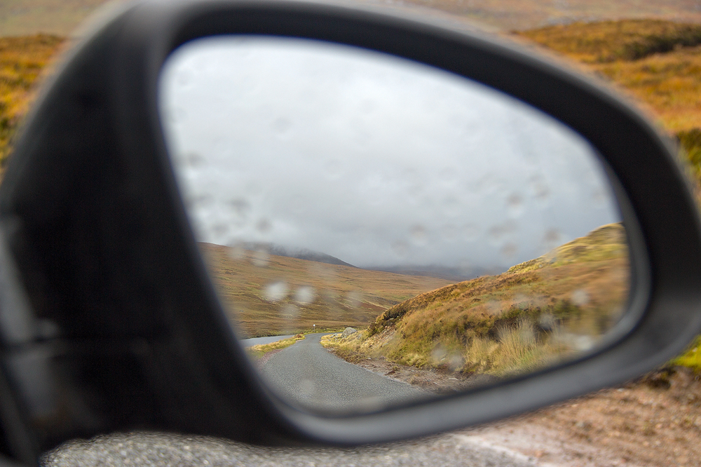
On the Skye tours, be sure to have walking shoes and rain gear. Usually a walk or even a short hike is included in the tours. But the ground on the Isle of Skye is peaty-muddy and some times you have to deal with sticks and stones. Still, the hikes are doable.
No long stops for lunch are planned. So either take something with you – that’s also good for the walks, or plan accordingly for more time. At many of the sights, there are also small coffee shops that offer coffee and cake.
Enjoy, and I look forward to comments.
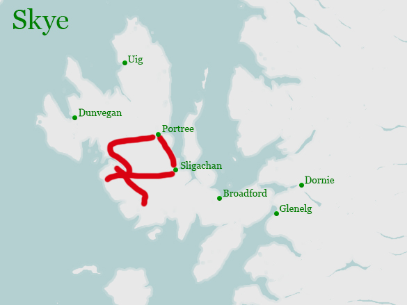
1. The North Island Tour (150 kilometers, 3 hours drive time, 8 hours total)
On this tour you can expect: Beautiful mountains, a famous bridge, the true ancestral home of the MacLeods (there can only be one) along with a beautiful park, an old village with thatched roofs and the smell of peat, the grave of a heroine and a grandiose rocky outcrop.
Starting point – Portree
It is recommended not to leave too late (9am at the latest), because of the hike at the end. Of course, you can turn the tour around, but Dunvegan Castle closes at 5pm in the afternoon – the mountain doesn’t.
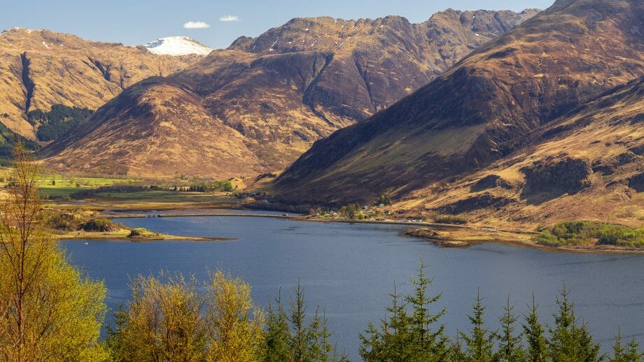
Station 1 – Sligachan Bridge (15 minute stop)
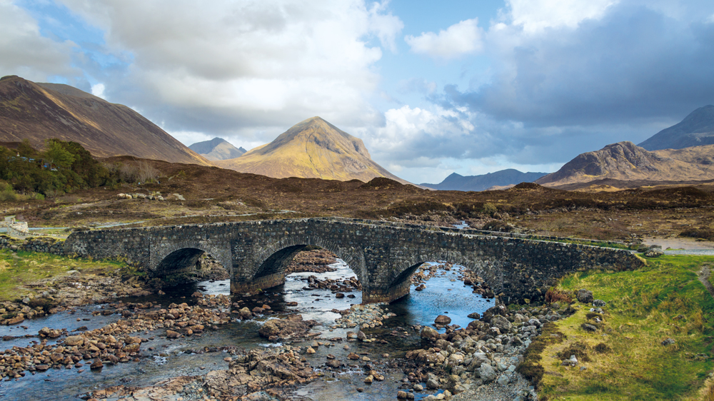
First we head south on the A87. Arrive at Sligachan, where the famous stone bridge and Mount Glamaig await.
Photo tip: Carefully cross the main road to Loch Sligachan and the campsite. From the side then take a shot of the stone bridge including the Cuilins massif behind it.
Station 2 – Macleods Tables (short stop on the road)
At the Sligachan Hotel turn onto the A863 towards Dunvegan and follow it. It goes past Loch Harport – on the other side you can see Carbost with the Talisker distillery – but we do that in another tour. So we continue on the road. There is a turnoff to Portree, which we don’t take either. Straight on through Struan. Shortly after there is the parking lot of Broch Dun Beag – if you started early you can stop here and visit the Broch. Otherwise keep going.
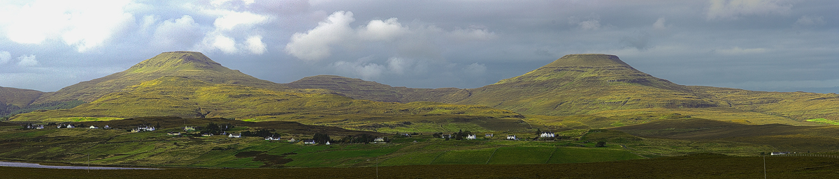
The flat tops of the MacLeods Tables then appear on the left. Pass Dun Beag over the River Os and through the hamlet beyond. It’s still over a hilltop, then a fence with a driveway soon appears on the left.
Photo tip: Stop here and take a shot of the MacLeods Tables. If possible maybe even panoramic shot as seen to the right.
Station 3 – Dunvegan Castle (about a 2 hour stop)
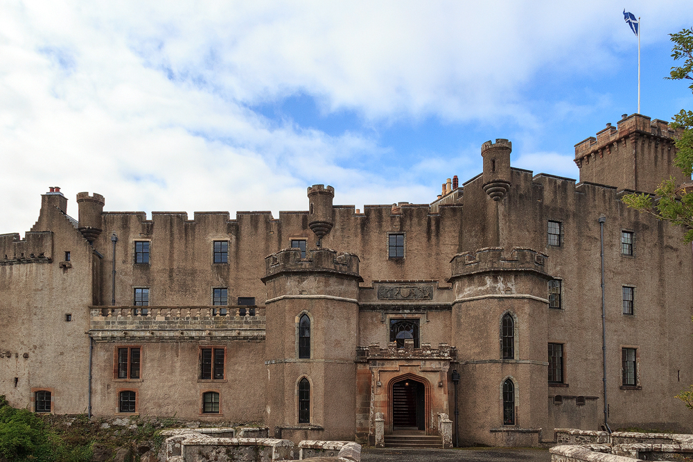
Now it’s only a stone’s throw to Dunvegan Castle. Just follow the signs, park your car in the car park and pay the entrance fee. Inside then stroll through the castle and admire the fairy flag. Afterwards still into the garden.
Photo tip: Behind, if one comes from the cellar of the castle, one can photograph again the MacLeods tables well. Otherwise, of course, the gardens in front of the Castle still give plenty of subjects. Photographing the Castle head-on is a challenge, as it’s hard to get a good position. A wide angle can help.
Station 4 – Museum of Island Life & Flora MacDonald’s grave (about 1 hour stop)
Continue towards Portreee again on the A850 until it meets the A87. There then turn left to Uig. From now on we are on the peninsula Trotternish. Past Loch Snizort to Uig. Apart from the ferry, there’s not much to see there.
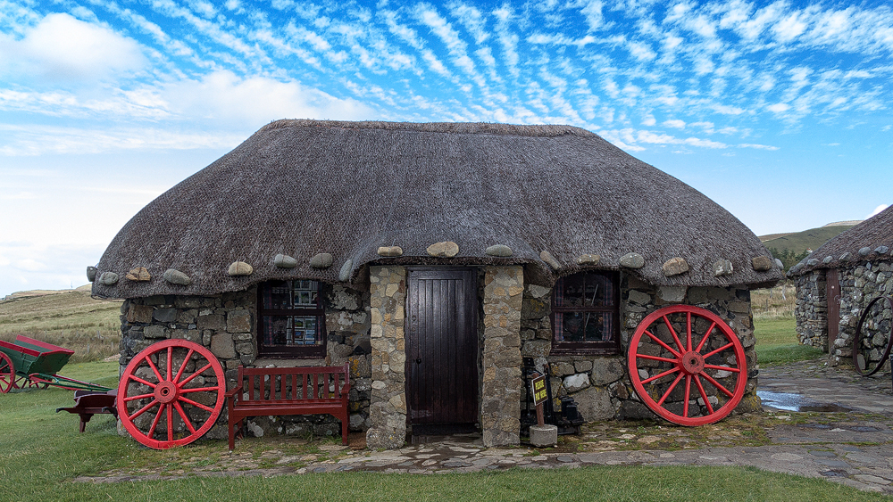
Here the dual carriageway A87 ends – or rather it goes onto the ferry, while beyond Uig the A855 continues as a single track road. The road first climbs some hefty altitude. A view of the bay at Uig including a photo is now possible. Continue through Kilmuir, then turn right into the museum car park. Here a village of blackhouses awaits you. It shows how the islanders used to live. One house is still in its original interior, it smells of peat fire. Later, if you walk further back down the side road, you come to Kilmuir Cemetery, where the heroine Flora MacDonald is buried. The memorial is fairly new. But all around the cemetery are other curious graves with old stone plaques.
Photo tip: Sure, the Blackhouse, which houses the ticket office and shop, with its red wheels in front, is great. But you can also snap some good photos of the village from a distance from the path to the cemetery.
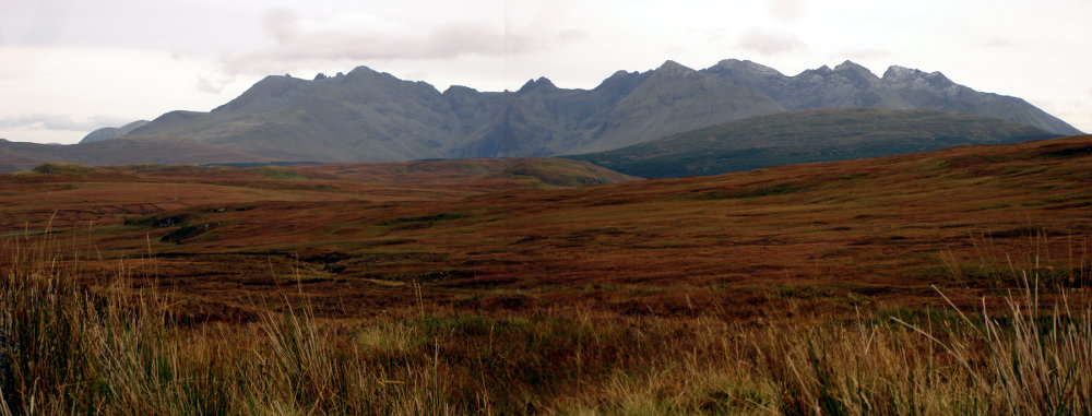
Station 5 – Trotternish Ridge (short stop by the road)
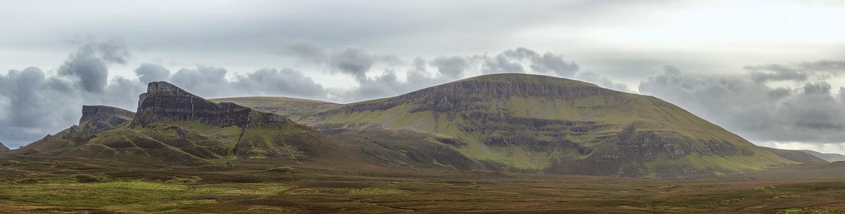
Continuing to follow the A855 north, we come to the tip of Skye. After about five kilometres the Trotternish mountains appear on the right hand side of the road with their beautifully shaped rocks. Somewhere in a safe place to park the car and enjoy the view.
Photototip: Unfortunately, cable lines are laid here on poles, which disturb the motif a bit. Nevertheless, it is worthwhile with a tripod to disassemble the Quiraing in two or three parts and as a panorama later put together. See picture on the right.
Station 6 – Quiraing Viewpoint (stop at the road about 15 minutes)
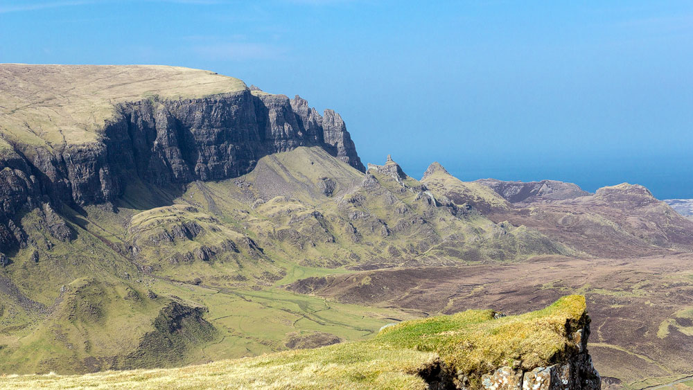
Following the road a bit further, you can also take a worthwhile detour, up to the Quiraing Viewpoint. The trail up there branches off the road just past Digg and is signed “Rathad a’ Bhealaich Cuithearaing” and “Quiraing”. The road winds up the mountain and already you can see the wonderful structures of the Quiraing. At the top there is a parking lot from which drivers can also enjoy the mountains.
Photo tip: If you have leisure, hike up the slope on the south side of the road a little. Photos can be taken even better from there.
Station 7 – The Storr (hike about 2 hours)
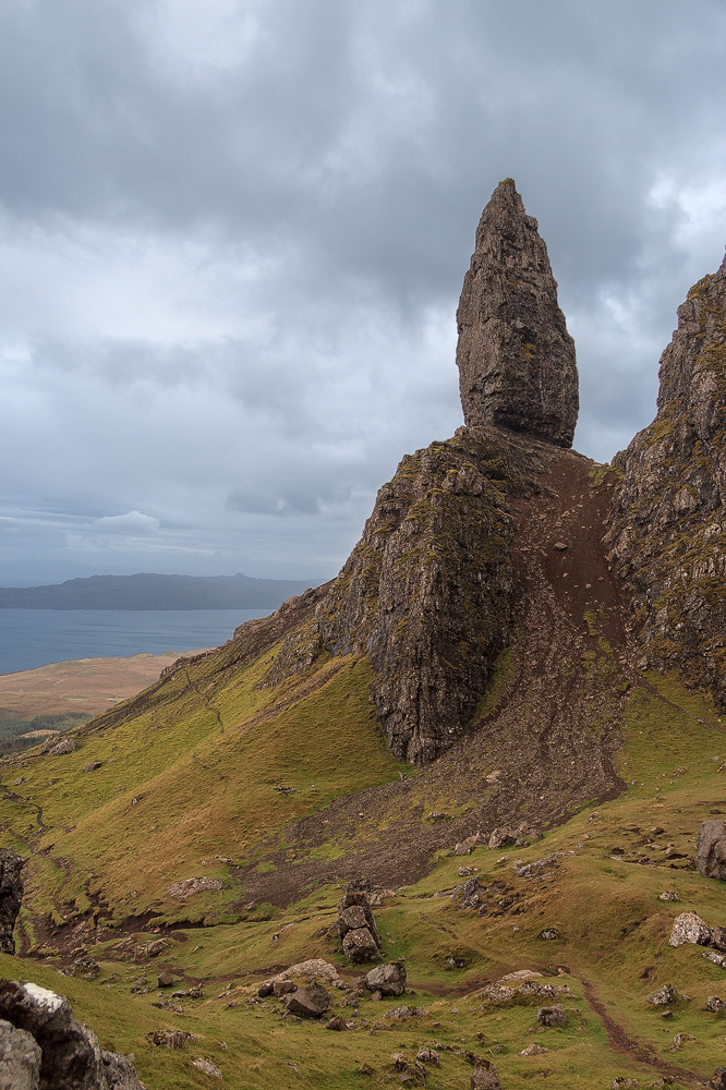
Continue on the A855, round the tip of the Isle of Skye and head south again. After about 28 kilometres you will see the Storr car park on your right. Park here, put on your walking boots and follow the path. The climb takes three quarters of an hour to an hour, depending on your ability, and is a little more challenging than a walk. At the top, the Old Man of Storr, a gigantic rock needle, awaits.
Photo tip: It’s best to leave the Old Man to the left for now and continue marching along the flank of the mountain. Eventually, a subject should present itself that combines the rock spike, parts of the mountain, and even the hole in the distance.
Final Station – Portree
After the descent back into the car and follow the road back to Portree. It’s done
2nd Eilean-Donan Tour with Mainland (170 kilometres, 3.25 hours drive time, 8 hours total)
On this trip we see snake and lizards, otters, a 40-year-old ferry, mysterious Iron Age stone buildings, five peaks lined up in a row and the famous Eilean Donan Castle. However, half of the tour is not on the Isle of Skye, but on the main British island.
Starting point – Portree
The tour starts in Portree, we head towards Kyle of Lochalsh, through Sligachan.
Station 1 – The road to Kylerhea (short stop at the road)
Following on to Kyle of Lochalsh. Passing the turn off towards Armadale we come through Breakish. Behind it a small road soon turns off to the right with the sign “Kylerhea” – turn in here. For about 10 kilometres one of the most beautiful roads on Skye follows. Especially the view shortly before it goes down to Kylerhea is gigantic.
Photototip: Be sure to stop here and take a photo.
Station 2 – Otter Hide (30 minute stop)
Shortly after passing the Kylerhea sign, a road branches off to the left, ending in a woodland car park. From here you can walk to the Otter Hide. This is a hut with observation windows about a kilometre away. With a little luck and patience, you can see otters or seabirds here
Station 3 – Glenelg Ferry (30 minutes time to cross)
Respect please, the lady lying down in the ferry harbour has already passed 40. And yet she is spry and reliable. So over to the other side, back to the main British island.
Photo tip:The ferry itself is the subject here, the landscape behind it the backdrop.
Station 4 – Dun Telve and Dun Troddan (30 minute stop)
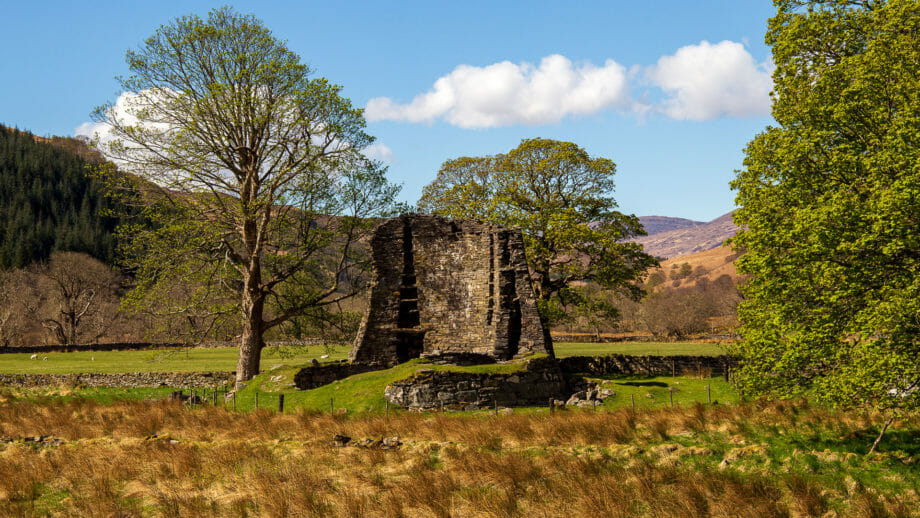
Once we arrive, follow the road to the right along the coast, not to the left into the mountains. First we want to look at the mysterious Iron Age towers. We pass the village of Glenelg. About two kilometres later the main road turns right over a bridge. But we go straight on to Glenbeag. Here the Brochs are already advertised. After two and a half kilometres, Dun Telve appears on the right, the more beautiful of the two brochs. About 700 yards further on is Dun Troddan on the left.
Photo tip: The Dun Telve Broch as a whole, but make sure the background is out of focus. Otherwise the broch won’t stand out enough against the forest.
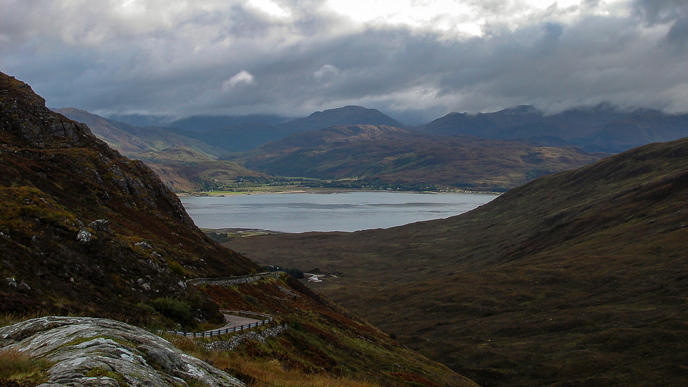
Station 5 – Mam Rattagan and the Five Sisters (15 minute stay)
Back to Glenelg and then follow the road towards Shiel Bridge into the mountains, it is the Old Military Road. An exciting, winding drive with beautiful scenery. Once over the pass, the Five Sisters of Kintail appear on the right and just a little later a car park on the left. But this is not yet the really good place. It comes a few hundred meters further on. There appears on the right hand an even larger parking lot with a magnificent view. Stop, enjoy the view!
Photo tip: The Five Sisters are a very nice motif. If you take the hole in front of it a little bit on it and even the Shielbridge, you also guess the height of the mountains and the depth of the valley next to it.
Station 6 – Eilean Donan Castle (stay 2 hours)
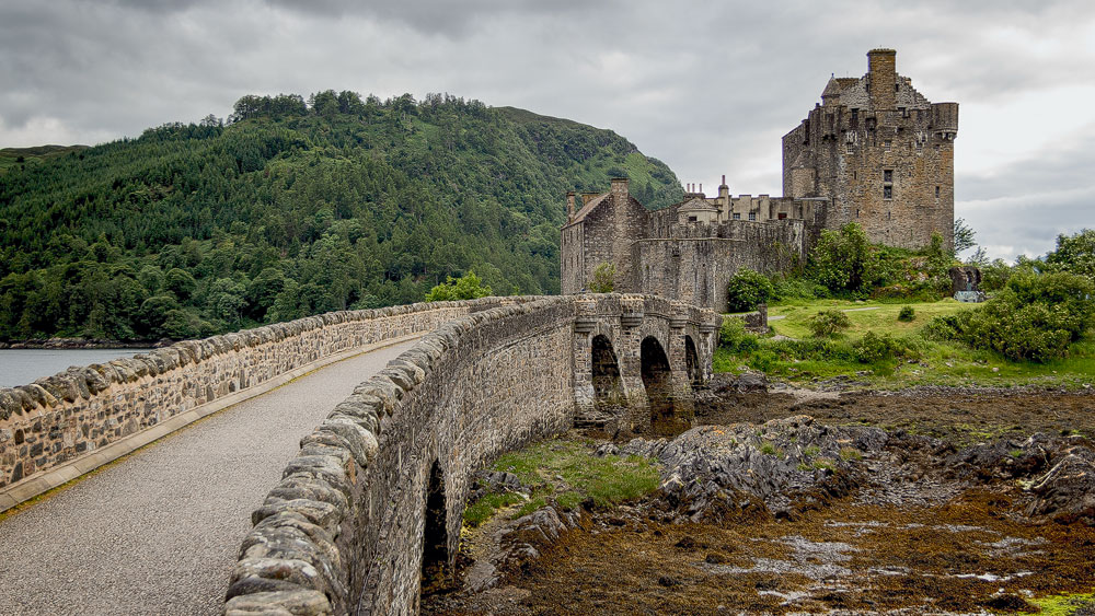
We head down off the mountain until we meet the A87 again at the bottom. We take that to the left, so back towards Kyle of Lochalsh and Uig. Along Loch Duich, Eilean Donan Castle soon appears. Here is a huge parking lot. Park the car, visit the castle, a guided tour is worth it.
Photo tip: First shot: If you drive past Eilean Donan towards Skye, there is a turn off towards Dornie just after. Drive up and then turn right again just before the Dornie Hotel and you’ll come to a small road that eventually opens up a wonderful view of the castle on the right. Second shot: Back on the A87 to Skye, over the bridge just after the castle. Behind it on the left is a small car park with a jetty for boats. From there you can photograph the Eilean Donan from the side.
Endpoint – Portree
But now back on the road – the A87 towards Uig/Portree. There’s another car park on the left at the road, from which you can catch a glimpse of the distant Skye Bridge.
Photo tip:You can get a decent shot of it with a good zoom – take in the mountains behind.
Then enjoy the scenery for a bit for the rest of the drive.
3. The Wonderful Water Tour (86 kilometers, 1.75 hours, 7.25 hours total)
This round trip sees enchanting pools where fairies are said to dwell, in the shadow of black mountains. Afterwards, take a good sip of the “water of life” whisky at a distillery tour before ending the day in a picturesque seaside cove.
Caution: This round trip, however, is for people who like to walk a bit.
Start point – Portree
Drive towards Kyle of Lochalsh until you reach Sligachan. At the hotel turn right towards Dunvegan on the A863. After about eight kilometres there is a turn off to Carbost on the left. We take it. Cross the river and turn left towards Glenbrittle. From now on we see on the horizon already the black mountains of the black Cuilins.
Photo tip: Already now from the road it is worthwhile to make pictures of the mountain massif. Later, at the parking lot, you won’t have them so head-on.
Station 1 – Coire na Creiche and the Fairy Pools (stay: 2 hours)
Still driving through the small forest, then the road curves to the right and a parking lot with a sign “Fairy Pools” is on the right. Park, enjoy the view. Here is the Coire na Creiche, where the last battle between two clans took place – between the MacLeods and the MacDonalds. And it’s here that the hike to the Fairy Pools, or Fairy Pools, is worthwhile. So put on your walking shoes and get going. The circular walk is eight kilometres long. If you like, you can then follow the road by car to Glenbrittle and visit the bay there – but better, you save your strength for the Talisker Bay later.
Photo tip: The pools are top motifs. Bring a camera and preferably also a travel tripod and ND filter so you can shoot the water “soft” with a slow shutter speed.
Station 2 – Talisker- Distillery (stay 2 hours)
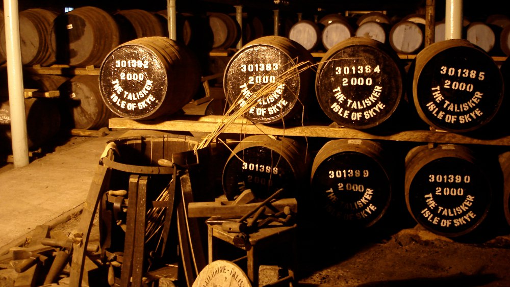
Take the road back to Carbost. There, follow the signs to Talisker Distillery. Park, join the guided tour, drink whisky, enjoy the lifestyle … only the driver should please stay sober. You can take a bottle from the shop for the evening.
Photo tip: At the end definitely photograph the storage room with the barrels. Bring polarizing filters to get the reflection of the glass out.
Station 3 – Talisker Bay (stay 1.5 hours)
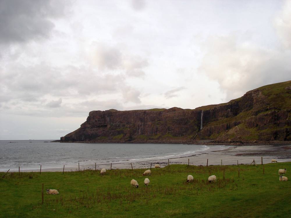
After the distillery, at the end of the village a road leaves to the left at the top, the sign points to Fernilea, Portnalong and Fiskavaig. Up the road a bit, but then do NOT turn right towards Portnalong, go straight on. On the left then risk a look at the waterfalls. Always straight until a sign shows the way to Talisker, there keep right. Drive the road to the end. Park, put on sturdy shoes and follow the sign “To the Beach”. The distance simply is one kilometre, then you are in Talisker Bay.
Photo tip: If you dare, you can always go further to the right. But this gets rocky and you have to climb. In addition, urgently always pay attention to the tide. There you come then to the waterfall, whose water often does not come to the bottom, because the wind leaves it. Besides, you have a good view of the bay.
Endpoint – Portree
Back to Carbost, then back onto the A87. If you like, for variety you can turn left after Carbost onto the A863 – to Dunvegan. Then to turn right again after a few miles to Portree.